Saturday 26 April 2014

Day 3 Rosthwaite to Grasmere (17.9 Km, total ascent 919m)

Rosthwaite to Grasmere (17.9 Km, total ascent 919m)

We spent the night at Nook Farm in Rosthwaite in Borrowdale.  The next day started with moderately heavy rain so after a hearty breakfast, we donned the wet weather gear and, leaving the warm comfort of Nook Farm, set off for Greenup Gill, a rocky stream we would follow up towards Greenup Edge, the highest point of our walk today at about 600m.  

We leave the warmth and comfort of Nook Farm in the rain

and cross over Sturdy Bridge.

 The sheep lined up facing the farm wall,  some protection from the wind and rain.

We headed towards the mist.

Past more cute lambs.

 The view back down to Borrowdale, fading into the mist.

We followed Greenup Gill with its many waterfalls.

We crossed many streams flowing across our path, both of us slipping on rocks at different times and ending up on our bottoms in the stream.  Thank goodness for the waterproofs which did a sterling job. 

Sometimes the path itself became a stream.

More waterfalls.

 Crossing another inflowing stream.

The view back down to Borrowdale as the rain and mist clear.

Then it is a slow walk across boggy terrain trying to avoid the wettest areas.

And a scramble up...

 to the top of Lining Crag with excellent views.

Panoramic shot from Lining Crag.

Then off across more waterlogged ground.


 From Green up Edge we have a view down to the col.  Navigation through here can be difficult in poor visibility but the mist had cleared and we had wonderful views.  Using our compass skills for the first time we confirmed our direction and navigated across to the col.


At the col, we decided it was fine enough to take the ridge walk across to Gibsons Knot and Helm Crag. 

 On the way we passed Brownrigg Moss.
 The views are stunning from up here.
We can see down the Easedale Valley (along the low route) to Grasmere.

We just love the Herdwick sheep, domesticated sheep native to Cumbria, they live in the fells and are territorial so they stay in their own area without the need to be fenced in (this called hefting).  As lambs they are black and fade to brown ashen by the time they are a year old at which stage they are called hoggs.  We've developed a soft spot for these sheep that Wainwright called the "hardiest of all fell walkers"

Herdwicks
Walking along the high route with views down the Easedale Valley to Grasmere.

Helm Crag lies ahead, one last climb before the steep descent into Grasmere.

The Howitzer at the summit of Helm Crag.  A tricky scramble is needed to scale the rock to the top so we gave it a miss with the excuse that we didn't want to risk injury at this early stage of the walk.  

This young man had no problems scaling the Howitzer.

And now we descend into Grasmere.  Stedman was right to write that the ridge walk is "longer than you might expect" and "the steep descent may well finish you off" and by the time we reached Grasmere we were ready for a rest but it was worth it for the wonderful views.

It's a steep descent down into Grasmere.

From Helm Crag we also had a clear view to the Grisedale Pass, our future route out of Grasmere between Seat Sandal on the left and Fairfield on the right.  Little did we know we would take the wrong path and end up at the top of Fairfield in the fog during the next leg of the walk..

The next leg of the walk, the pass between Seat Sandal on the left and Fairfield on the right.

 But for now it is a rest day at Rothay Garden Hotel in Grasmere.

Friday 25 April 2014

Day 2 Ennerdale Bridge to Rosthwaite (25.8 Km, total ascent 614m)

Day 2 Ennerdale Bridge to Rosthwaite (25.8 Km, total ascent 614m)

Today, after a tasty breakfast at Thorntrees, taking our packed lunch, we left Ennerdale Bridge and walked to Ennerdale Water, to follow a path along the southern edge of the lake.  It was cloudy and cool, but not raining.


There were nice views across the water to the fells, with their reflections in the water.  Would be even better on a fine clear day.


At first there was a nice path to use.


We soon came to the  rocky outcrop called Robin Hood's Chair with Bowness Knott across the lake.


And we had a clear view of the distant end of the lake, our first target.


We expected any easy stroll along a lakeside path, but that isn't the case.  The path soon became rocky and uncomfortable on the feet with a need to watch your footing.


As we ascended the track towards Black Sail Youth Hostel, we had views back down the valley to Ennerdale Water and Angler's Crag, with the town of Ennerdale hidden beyond.


Then Black Sail Youth Hostel appears ahead.


By lunchtime we reached Black Sail Youth Hostel, a place where you can sit and have a cup of tea or coffee.  However you cannot use the toilets as they are locked until 5pm.  So you have to hold on until you get to Honister Slate mine a few hours later.


Elaine finds the less obvious path up to Loft Beck.  There is a more obvious trail heading to the right which has led many walkers in the wrong direction, requiring mountain rescue services.   Despite this and trail being adjacent to the youth hostel, the correct path is not signposted so no doubt others will continue to make the same mistake,.  It is easy to see why people miss the correct path if they are not aware.


Then we had a steep climb up along side Loft Beck.


Looking across to Haystacks, an adjacent fell.


Another view of Haystacks with High Crag beyond.


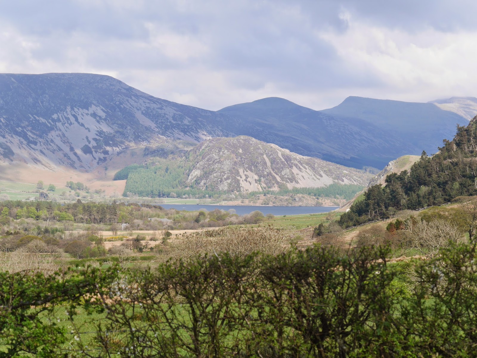
The weather was clear enough to give us fine views down to Buttermere (the lake in the foreground) and Crummock Water in the distance. Melbreak is the fell beyond Crummock Water.


We descend down a steep disused tramway previously used by the slate mine.  The slate mine is a great spot for a break.  Toilets and a cafe as well as a shop where we picked up souvenir Coast to Coast slate coasters.


While we were at Honister Slate Mine, the rain started so it was time to put on the waterproofs and continue down the hill into Borrowdale.

Though there have been a couple of places earlier today that are well known for causing navigational difficulties, there was no signage for guidance, but now we are walking along a clear path with no alternative path to take, there is a clear sign pointing the way for the coast to coast.


A couple of Yurts in Borrowdale.


We walked through fields of cute lambs today as we entered Rosthwaite in Borrowdale.  At the Scafell Hotel for dinner Lamb Henry was on the menu.  I couldn't bring myself to order it, because I was sure I had seen Henry (or at least one of his mates) out there in the fields just a couple of hours earlier.  Tonight I went vegetarian.


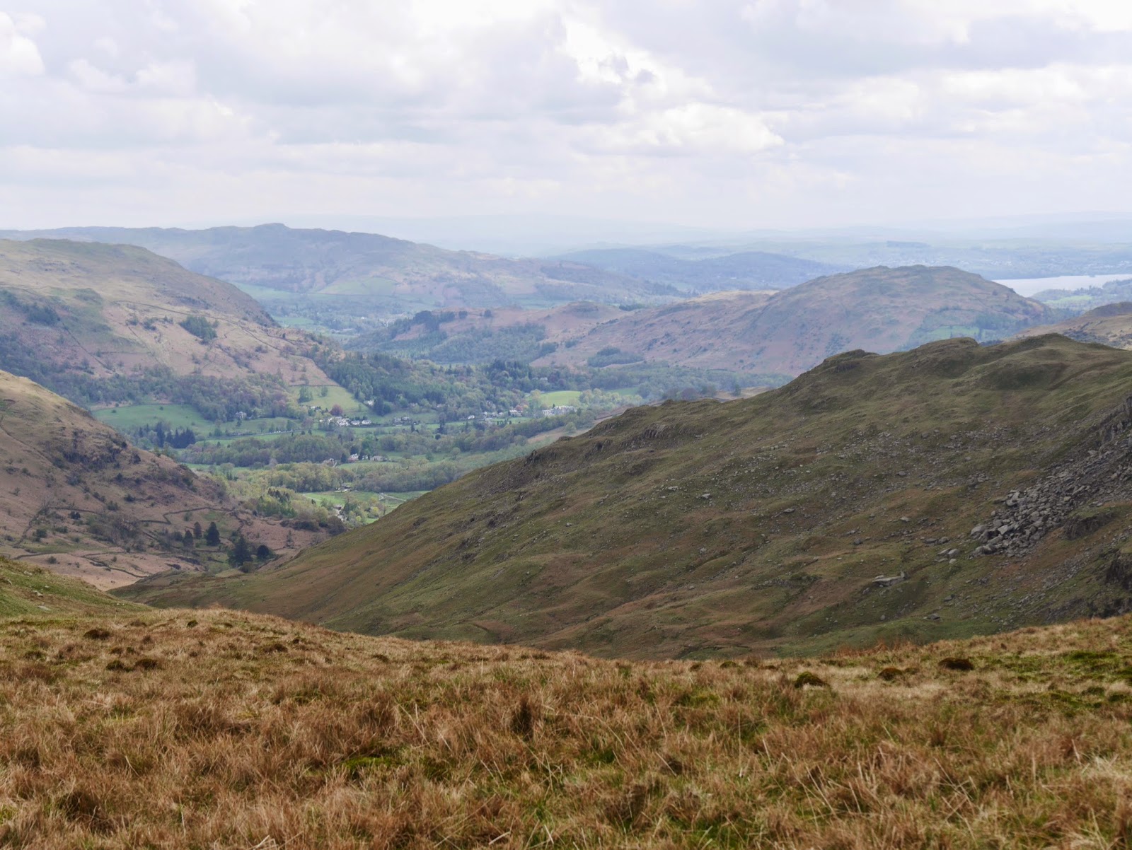
A look back up towards where we have come from and we are glad we got down off the fells before the cloud rolled in.


We had dinner at the Scafell Hotel in Rosthwaite with John and Winna (from Essex) and Geoff and Karen (from Wales), two couples also doing the Coast to Coast, who we had met the day before at the B&B in Ennerdale Bridge.

Thursday 24 April 2014

Day 1 St Bees to Ennerdale Bridge (25.6Km, total ascent 884m)

Day 1 St Bees to Ennerdale Bridge (25.6Km, total ascent 884m)

When we awoke, it was cloudy and threatening rain, but by the time we had packed and eaten a good breakfast, the weather had cleared and we had a beautiful blue sky for the start of our walk.
The route 
We each had a photo beside the sign marking the official sign for the start of the Coast to Coast although by now we had already clocked our first kilometre from our B&B.

Gary at the official start of the Coast to Coast.

Then it was off to climb the path up to St Bees Heads, looking so much prettier today in the glorious weather.

The route first takes us north up and  along the Heads, clocking up more kilometres but not gaining any ground in terms of our easterly path across England.  The scenery is beautiful in this weather and we saw many seabirds nesting along the coastal cliffs.

St Bees Heads

Beyond Fleshwick Bay, St Bees Lighthouse appears in the distance.
I pop down to Fleshwick Bay which divides the South and North Heads and get a photo of my boots in the Irish sea for the last time.


And admire the unusual erosion of the rocks on the pebbly beach.
There are dozens of guillemots nestled on the rocky cliffs.

Then it is up onto the North Head to continue to St Bees Lighthouse

We continue north along the coast before turning east, past a Rhea farm.

As we head east, the hill climb for the day is seen ahead, Dent Fell at the edge of Lakeland.


We passed under the continuation of the railway line that brought us to St Bees and through rather muddy fields of sheep, past Stanley Pond.
And under an old railway line which is now a cycleway and offers an alternative, more pleasant walk into or around the town of Moor Row..

But we decided to continue on the original route into the town of Moor Row, with a brief glimpse back to St Bees, which looks closer than it really is in this photo.

 On the outskirts of town there is a sculpture dedicated to the Coast to Coast.

And the bald top of Dent Hill looms closer.


Soon an unofficial sign points us down the correct path.
At Cleator we nip into the local store to grab two of the last lukewarm potato pies for lunch and head to the base of Dent Hill where we find a spot to sit and have lunch.

Then it is time for the climb up Dent Hill.  Not high at 352 metres but still a stiff climb at this stage of the days walk  The path up through Blackhow Wood is very boggy (much boggier than it looks below) and intermittently we dodge into the trees to escape the boggiest areas.

The path up through Blackhow Wood

The views from the top are great and we can see Longlands Lake in the foreground and all the way back to St Bees Heads where we started today's walk.
And ahead we see the fells of the Lake District, through which we will walk for the next few days.

Another helpful sign along the way. The directional signs have disappeared but a couple of painted arrows point the way.  One can only assume they are for the Coast to Coast??

A little further on we use a high stile over a deer fence (No deer to be seen though).

And as we descend to Nannycatch Gate we have another great vista.

There is time for a rest along Nannycatch Beck.

As we near Ennerdale Bridge we pass the Blakeley Raise or  Kinnerside Stone Circle, reconstructed in 1925. 11 stones in a circle 18m diameter.  There are more than 50 stone circles in Cumbria.

Kinnerside Stone Circle.
And shortly after, the town of Ennerdale bridge comes into view.  The feet are getting pretty tired by now.

And as we descend into Ennerdale Bridge we get a glimpse of the start of tomorrow's walk along Ennerdale water which we can see in the distance. Beyond it, from left to right, are Great Borne, Bowness Knott, Starling Dodd, Red Pike and  High Stile. On the right peeping just above the trees is Angler's Crag.

Looking across to Ennerdale Water, contemplating tomorrow's walk.

We are glad to see Thorntrees, our B&B for the night. Billy and Rosaleen make us very welcome.

That evening we enjoyed a good dinner at the Shepherds Arms.